We spent Thanksgiving with Wade’s family in Central Coast this year. It was my first time in the area, somewhere between San Francisco and Los Angeles. We drove south from Humboldt with Luna and going through San Francisco and over the Golden Gate Bridge was pretty trippy. I’ve never seen this city, or the bridge so empty. It didn’t take very long to get through, and we continued south to San Luis Obispo.
On this trip I got the chance to see the beautiful sunsets that I’ve only seen from the photos Wade’s mom has sent me. That orange is for real. I also visited Morro Bay, Cayucos, Montaña de Oro, and further afield, Big Sur, Pacific Grove, and Monterey.
Just before this trip, I lost my drone in the strong coastal winds and so I had the replacement sent to his parents. Bushwhacking 101 – Wade and I had a quite a day hunting it down and retrieving it. What an emotional roller coaster of denial, hope, loss, guilt, and elation, with Wade discovering “Froggy” on an isolated beach, among similarly-coloured rocks. Getting my replacement drone back, I also got to film the fall colours near Bradley en route. Quite a trip.
Morro Bay
The day after Thanksgiving, while Luna stayed at the house, Wade and I went to Morro Bay and then further north to Cayucos, his old stomping grounds.
Morro Bay is about a half-hour drive from Pismo Beach. It’s also less than twenty minutes from San Luis, and from here to Morro Bay are the peaks of the Nine Sisters. These make up a chain of hills and are volcanoes that were active between 20 and 26 millions years before. Morro Rock, dated at 21 millions old, is the furtherest western peak of the Nine Sisters, or Morros.
Like many visitors, we went to the parking lot where Morro Rock is. The bay here supposedly did not exist at the last ice age. The sea level was lower and the shoreline was further out. The parking lot at the rock is large and it’s usually easy to find a spot, even “front row seats.”
It’s a popular place to watch the enterprising seagulls, bold ground squirrels, and all the surfers braving the water in wetsuits. The sandy beach is also great for kids and dogs to play. If the mist and fog haven’t hidden them, you can see the further peaks.
Other surf spots in this area include the Jetty, which is south of the rock, and Morro Strand, two miles north of it.
Driving from Highway 1, we passed the waterfront of the fishing village of Morro Bay. Restaurants, shops, galleries, and eateries line Main Street. It was crowded, this Thanksgiving weekend. If this is more your speed, find a parking spot on the street or in one of the lots and stretch your legs here. Since we were going to Cayucous, we didn’t linger.
Morro Bay and Montaña de Oro State Parks are renowned for their spectacular scenery
produced over millions of years by volcanic activity, plate tectonic interactions (subduction and collision), and erosion that have shaped this unique landscape.Geological Gems of California State Parks | GeoGem Note 20 [download PDF]
I don’t know very much about geology. GeoGem Note 20 provides some interesting background about Morro Bay and Montaña de Oro.
Montaña de Oro
The next day was bright, sunny, and warm again. This seems to be a great time to visit the Central Coast. Wade said to bring my camera and I also brought along my DJI gimbal to use with my iPhone 11. Learning to do videos was my 2020-era skill upgrade, I suppose. Wade’s dad also brought his Go-Pro. It was a Father’s Day gift this year so I had company.
Montaña de Oro State Park is located fifteen miles west of San Luis Obispo and is closest to the town of Los Osos. (For GPS, use 3550 Pecho Valley Road Los Osos) Translated to “Mountain of Gold”, the name refers to the area’s spring wildflowers that bloom golden. These flowers include poppies, sticky monkey flowers, mustard, lupines, and wild radish. Discover Spring Wild Flowers in California State Parks provides information on the kinds of flowers that bloom in each park in the state. Very handy.
Covering over 8,000 acres, this park has a lot of wildlife (Wade warned me not to stray off path into the bushes because of, rattlesnakes), trails for hiking, biking, and horseback riding, and a campground to enjoy the quiet and starry skies, far from light pollution.
(Note: dogs are not allowed on the trails/park, and only in the campground)


According to the Parks website, Montaña de Oro is one of the largest in California. I think this is a typo. The largest state park in California covers 585,930 acres. This is Anza- Borrego Desert State Park, about two hours northeast of San Diego by car, near Borrego Springs. The next largest is Henry W Coe State Park with 89, 164 acres. The closest city to Henry Coe or Coe Park is Morgan Hill. Montaña de Oro doesn’t even break into the top ten largest. So the typo is probably that it is the largest in San Luis Obispo County, rather than the whole of California.
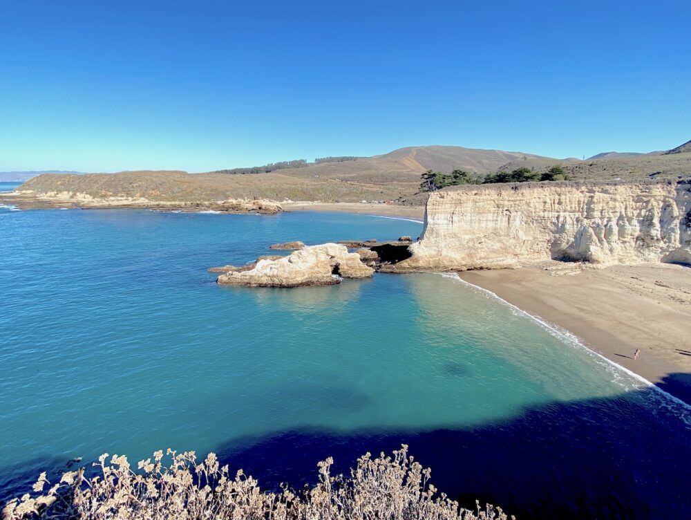
We took a brief walk to the cliff overlooking the ocean. The view was stunning, with the rugged and dramatic cliffs against the deep blue of the ocean and sky. Year-round there are whales to spot, maybe dolphins. Gray whales migrate annually from Alaska and can be seen from fall to spring. Bring binoculars.
There are many trails to explore Montaña de Oro. For an easy one, you can continue from the cliff on the Bluff Trail, which is an easy flat “loop” along the ocean. There are also side trails to discover sea caves and beaches.


Montaña de Oro State Park | Anza- Borrego Desert State Park | Henry W Coe State Park