The Māhā‘ulepū Heritage Trail is a coastal trail on the south shore of Kaua’i. The views are beautiful and it’s an easy trail to walk. It’s also easy to get to, starting at Shipwreck Beach near the Grand Hyatt Kaua’i Resort. Or you can start at the other end. There, you can find parking near the CJM Stables. I started at Shipwreck and walked the whole trail and back, which is about four miles.
Shipwreck Beach
Shipwreck Beach is next to the Grand Hyatt. Its name came from the 19th century shipwreck of the “King Kamehameha.” This part of the coast has actually been the site of various shipwrecks.
At 21° 52.374′ N, 159° 26.508′ W. is historical marker number 7. Put up by the Po‘ipū Beach Foundation, this marker has this inscription – “The bay before you—named Keoneloa (or ‘the long sand’)—is the site of one of the oldest known Hawaiian occupations on Kaua’i, a temporary fishing camp, dating to A.D. 220–660.”
Shipwreck or Keoneloa Beach is part of the Keoneloa Bay.
(List of historical markers in Po’ipu)
There is a small parking lot right by the beach. It’s often full and the last time I was here, I parked along the road instead.
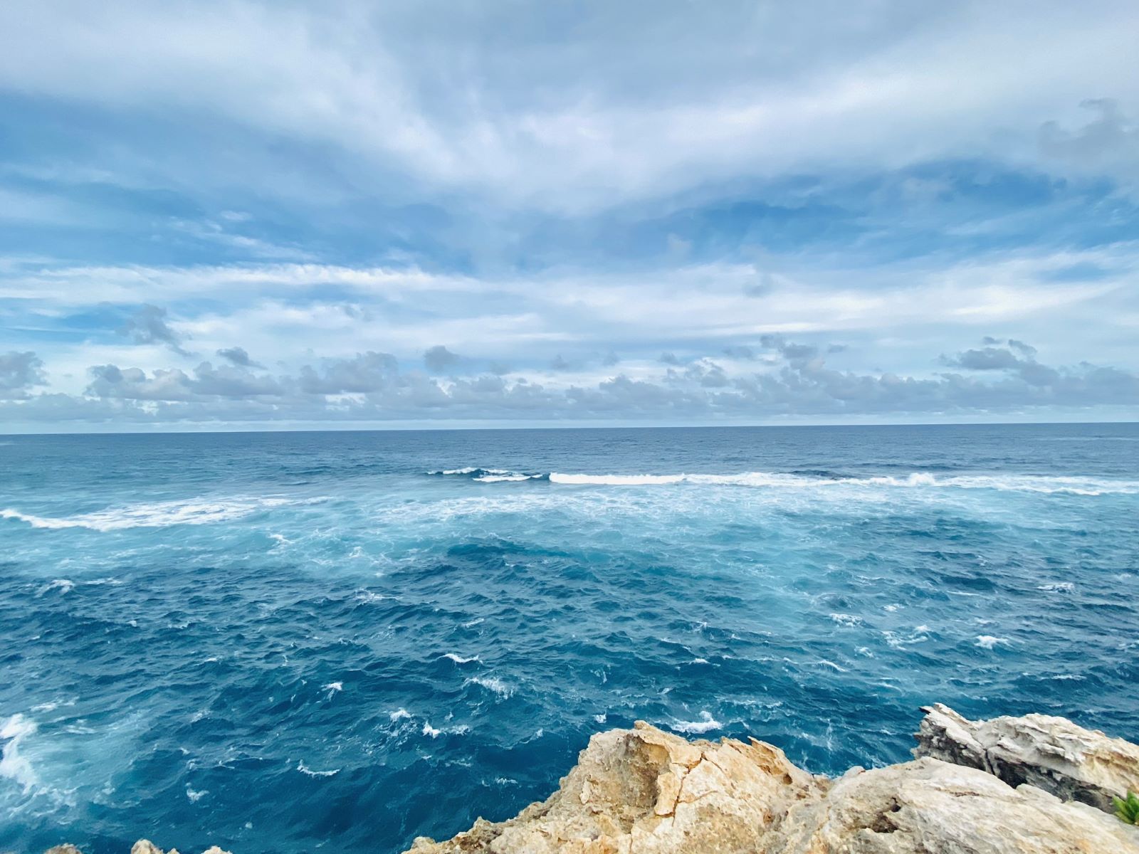
This is a beautiful beach, though the ocean is powerful here. There are also no lifeguards here. The rip tides and short shore break make this beach dangerous for novice and even intermediate surfers. The surf is no joke though when it’s mild, shallow wading is mostly safe for visitors. Because of the strong ocean conditions, Shipwreck is not known for snorkeling. If you’re an experienced surfer, this may be a good place to check out.


From the beach, you can also see people jumping off the forty-foot limestone cliffs. There are also some lower jump points. For cliff jumpers this is probably the best spot on Kaua’i. However be sure to check for ocean conditions as shifting tides make a difference.
Wade and I headed towards to the trailhead which is somewhere in the grassy picnic area, where the roosters roam. It’s not clear where the trail is, so keep heading east, away from the beach. When the trail splits, we stayed right which led us to the limestone cliffs. The left fork stays inland. This was the one I took coming back to Shipwreck Beach.
Limestone Cliffs
The first stop is atop the limestone cliffs of Makawehi Point. These were once sand dunes that have lithified into cliffs, made jagged by wind and water. There are some incredible shapes. More photos from my 2019 trip.
If this is as far as you get on the Māhā‘ulepū Trail, it’s still worth it. This part is one of the most crowded on the trail and lots of people take photographs and selfies.
This is as far as Wade got. He was going to play it by ear and when he returned to the beach to check out the waves again, I continued on.
For my 2019 Kaua’i trip, I picked up Tanis Helliwell’s book, The High Beings of Hawai’i. I had just heard her talk in Vancouver and I was intrigued by her mystical encounters. In this book. she wrote about meeting the menehune in Kaua’i. One of the spots was along the Māhā‘ulepū Trail.


Heiau Ho’oului’a is so ancient that its true name has been forgotten. Now called by its generic name, meaning “fishing temple”, it’s thought that long ago there were two grass huts here: One to give offerings to the god of the sea, and the second being the living quarters of the kupuna, or elderly person, who did the offerings.
Tanis Halliwell, The High Beings of Hawai’i
Heiau
A heiau is a sacred place. Driving down to Kapa’a from home, we pass by Poli’ahu Heiau. The oldest one on Kaua’i is Holoholoku Heiau, believed to have been built in the 1300s. Located at the Wailua River State Park, this ancient temple was where human sacrifice was made.
On the Māhā‘ulepū Trail, there is a heiau. I was walking alone and kept to the trail to be respectful. There was definitely a strong feeling. I wasn’t really alone. When I checked Tanis Halliwell’s book, she shared that “I immediately saw the guardians of this heiau. They had committed to that role while alive and, now that they were dead, they fulfilled their function in the astral world.”
On my way back, it was around sunset. I was alone again and then all of a sudden, a couple of groups of people suddenly appeared behind me, somehow caught up to me, probably eager to get back to Shipwreck beach before dark. The trail isn’t lit and sunset is usually 6:30-7:30PM.
The trail was empty, and I stopped abundantly to watch the ocean from the cliff. The ocean’s colour was unbelievable and captivating.
For Tanis, it had gotten too hot and she turned back. While she stopped in a grove of casuarina pine trees, she met with the menehune. “While looking me in the eye, the female pressed her nose and forehead to mine and shared my breath. This is called the honi by Hawaiians where two beings share the hā, the divine breath of life. It is a beautiful and sacred greeting and, as I reciprocated, my heart opened wide.”
Her book has been a great way to learn about this place I call home and about the mystical beings whose home it is.


Māhā‘ulepū Beach
The trail goes through the Po’ipu Bay Golf Course. There are signs warning of eroded cliff faces. Sometimes you also see Hawaiian Geese or nene.
Soon I was off the golf course and entered a more covered trail with tall dry grasses and brush. The trail goes through a number of different terrains, which is one reason I enjoy it. I didn’t actually know where I was going. Walking in the red soil, I found my way to a vista point to gauge how far I was and texted Wade to let him know where I was. Along the way, I found several trucks parked near to the cliff edge. Some were camping, maybe for the day.
It turns out there are a couple of ways to descend onto the Māhā‘ulepū Beach and bay. It’s a long beach with three sections, the closest to the trail being Gillin’s Beach.
Gillin’s Beach is named after Elbert Gillian. He was a civil engineer at the Koloa Sugar Plantation. He built a house in 1946 after he acquired 3/4 acres of land. 1992’s Hurricane Iniki made landfall on Kaua’i in the south-central regions. The Gillians’ family home was one of over 1,400 homes destroyed. More than 14,000 homes suffered some damage. Iniki means “strong and piercing wind” in Hawai’ian. This hurricane had winds up to 362 KM/h and hit Kaua’i the worst out of all the islands. It took seven lives and caused over $3 billion in damages.
In 1994, the Gillian family rebuilt the house. You can rent this house for your own hideaway or intimate event.
When I got there, a couple was hiking down from another trail with their surf boards and another couple was stationed in their beach chairs in the shallow water.
There is no shade on the Māhā‘ulepū Trail and it got pretty hot. So, it was a relief and felt cleansing to get into the water. Or at least in the shallow areas protected by the reef.
There are also secluded beaches along the trail that you can stop at. Some more private than others. Earlier, I did just that. I found my way to a cove. Every chance I get to be barefoot and get in the water…


The Māhā‘ulepū Trail is a great way to see the south shore. While the trail is two miles each way, you can start at either end or go as far as you want. It’s an easy walk though some people may find the sand dunes challenging. I just had on Tevas and I took with me a camera, phone, and water. This was one of my favourite places for photography on Kaua’i. If you’re into kite-surfing, surfing, fishing, or hiking, the Māhā‘ulepū Beach is quite a gem at the end of the trail for you.