Kaua’i is the Garden Island. Natural and lush beauty. It’s no wonder Kaua’i was the location for so many films, including several Jurassic Park movies. Can you believe the original one came out in 1993? 1993. The dramatic and breathtaking landscapes are awe-inspiring, inviting us to exhale and reconnect with nature and our own nature.
Quick Links :: Trip Details | Planning | Tips | Shipwreck Beach & Maha’ulepu Heritage Trail | Kalapaki Joe’s | Waimea Canyon
Trip Details
- 8 days December 2019
- sightseeing and a retreat
- based in Kapa’a (east part of Kaua’i)
- WestJet direct from Vancouver (about 6 hours)
Planning
I booked two things : Jeep rental and mountain tubing. Well, three, counting my retreat which includes accommodations.
I also prepped by skimming the Lonely Planet book for an orientation, overview, and cursory ideas. To refine the to-see list, I read Tanis Helliwell’s Higher Beings of Hawaii. I also searched #Kauai on Instagram. This gets you a lot of Pierce Brosnan photos.
Mountain Tubing
I saw a FB video of riding an inner tube in Kaua’i years ago. You’ve probably seen it. Remnants of the sugarcane plantation, these are a network of canals that were repurposed as a commercial venture. It’s promoted as a fun family activity. The company that takes you out (it’s private land) is Backcountry Kaua’i.
Jeep Rental
It was a bit trickier as I was landing at 10:30PM. Booking for a 11PM pick up eliminated several rental companies, though they probably all stay open late for late arrivals as Dollar did. My plane ended up being 1.5 hours late!
I rented from a local company, Discount Hawaii Car Rental. Their TripAdvisor reviews were great. When I got my travel insurance from BCAA, they said my car rental insurance policy, from Rental Cover, was fantastic. $60 CAD for 3 days. Between that and the credit card coverage, I was set.
Tips for Kaua’i
Getting Around Kaua’i
There is primary one highway around the whole island. However the Nā Pali Coast is inaccessible by car. You cannot drive all the way around Kaua’i. In the North Shore, the road ends at the entrance to Haena Park.
Entry into and parking in Haena State Park requires a reservation. Plan well in advance. They book up very quickly. This includes just going to Ke’e Beach.
Going the other way, toward South Shore, you can continue to the west side for Waimea Canyon. Beyond that there is Polihale.
Weather
It is a small island, in the Pacific Ocean. Weather conditions change quickly. On my 2019 trip, the forecast looked pretty dismal – overcast and rainy. However, we were never once rained on. It mostly rained during night, like a lullaby, or while we were on the road. It’s wetter in the winter so be sure to check hike conditions before heading out. The hike I had looked at doing with the Sierra Club got closed because of the heavy rains. This mean muddy and higher waters to cross. I brought Tevas.
And if you are a photographer, head to the shoreline. Stormy weather is so great for surf break photography. Amazing water forms. Check for the direction of swell and which beaches are the safest.
Backcountry Kaua’i | Discount Hawaii Car Rental | Rental Cover
South Shore
From Kapa’a, we turned south past our entry point from the night before, Lihue airport. Destination: Maha’ulepu Heritage Trail on the South Shore.
It felt great driving the jeep, cruising the speed limit of 25 miles per hour. It was my first time driving a Jeep. Somewhat a learning curve – like where the window controls are. For about 15 minutes, before we figured that out, I felt claustrophobic and trapped. The moment I got the windows down was amazing.
The skies were still overcast when we headed out. The views, however, kept us at the edge of our seats. Every turn, a spectacular vista. I constantly had to remind myself to keep my eyes on the winding road since I was driving.


Shipwreck Beach, Maha’ulepu Heritage Trail & Kalapaki Joe’s
We easily found parking near Shipwreck Beach, where Maha’ulepu Heritage Trail begins. From Keoneloa Bay where we were to Kawailoa Bay.
As we approached the beach, we found the parking lot almost full and lots of people coming and going. The beach itself was rather empty; most people seemed to have come for the weathered limestone cliffs and to hike the trail.
Tanis Helliwell writes : “The walk is very scenic and parallel the ocean along sand dunes that are composed of limestone and sandstone pinnacles.”
We followed a path, past the omnipresent chicken to the cliffs, walking on lithified sand that dates back 100,000 years. The landscape indeed was breathtaking. The sand dune cliffs, formed in the Ice Age, were a sight to behold. I felt this compulsion to sit right at the edge, peering down and beyond. Seeing god.
The winds were strong, conversations carried out to the seas. Parking my Canon safely on the ground, I ventured further with my iPhone and Sandmarc hybrid filter to capture the hypnotic view. Watching the waves break onto the cliffs and rocks below.
The book Ancient Sites of Kaua’i shared that a petroglyph field is hidden beneath the sands at Shipwreck Beach. Rarely revealed, they were exposed for 10 days in the summer of 1897. 67 units were counted and documented. A sandstone slab is supposedly in the lobby of Grand Hyatt Kaua’i Resort, just next to the beach. We didn’t check it out; I only read the book after our day out. If you do, let me know!

The rainbow deva at the waterfall had instructed Tanis Helliwell to find the mo’okane and menehune at the dunes. She walked as far as Heiau Ho’oului’a, the “fishing temple” believed to be where offerings to the sea god were made. There are still several heiau on the island; approach with respect. Ask for permission to enter; you may encounter guardians. If unsure, stay at the perimeter.
With a noon-ish start, whipped by the salty winds, food was on our brain. The plan this time wasn’t to hike the 6 KM trail anyway, even though the remote Maha’ulepu Beach was an enticing end point. Then there are coves, dunes, petroglyphs, and even monk seals along the way. And the fishing temple Tanis Helliwell stopped at. The trail is there for us to return to, when the timing is right.
Here’s what I’ve learned about travelling – follow the energy, enjoy what shows up, and know it’s perfect. If we are meant to experience something different, we will return or we will find it elsewhere.
According to the elder who communicated with Tanis Helliwell, the mo’okane are shapeshifters and shamans descended from dragon-like beings (the mo’o). Mo’okane is also the name of the mo’o in human-like form. In Hawaii, the four main tribes live by the river, mountain, beach dune, and devas live in a more subtle dimension. The menehune, some believed to be Hawaii’s elemental beings, were taught by the mo’o, and in turn taught the original Polynesians.
I read in the book Ancient Sites of Kaua’i (another great book by the way) that the menehune were a mythological people, small and dark-skinned, and expert stone builders responsible for many of the heiau. They supposed came on a cloud, landing from a floating island, or had walked across a Pacific continent that extended to New Zealand before it flooded.
If you are getting confused, know that Tanis Helliwell also sought for clearer definitions. This is what she was told – “Menehune, mo’o, and human ancestors in the astral realms are all guardians of the Earth. We travel back and forth to each other’s realms to work together and with elementals. All of us are ancestors; however it’s essential you do not think of us in the past tense, because we ancestors are alive and influencing you and others in the present.” It’s a human thing to seek clear delineations and definitions. We classify to understand; ironically in doing so, we cut off access to deeper wells.
Kalapaki Joe’s
All we knew was that we needed food! We thought about heading out to Grand Hyatt as the views at Kaua’i resorts are legendary. We also wanted to try something local. Our navigator steered us to a great find, Kalapaki Joe’s. A hot happy-hour joint, we later discovered from Kevin our Backcountry Kaua’i guide. Between the three of us, we shared a delicious fish taco, fish salad, and cauliflowers.
Maha’ulepu Heritage Trail | Kalapaki Joe’s
To the West


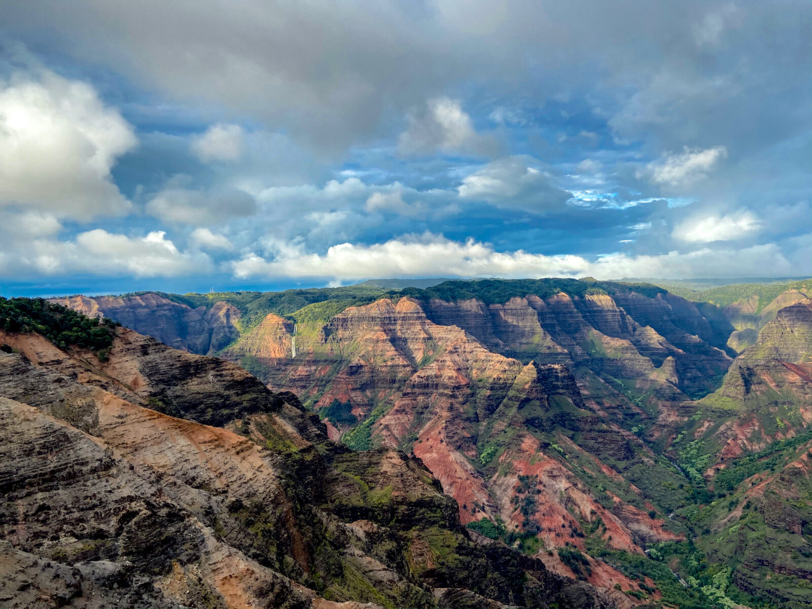
Waimea Canyon
After a fulfilling lunch, we jumped into the jeep and headed west to Waimea Canyon. Waimea, meaning “reddish water”, as deep as 3,000 feet in some places, was formed both by erosion and the collapse of a volcano. Did you know Kaua’i is the oldest of the Hawaiian islands?
It turns out to be the home island of my friend’s great-grandmother – mother lineage.
The Waimea Canyon State Park itself is nearly 1,900 acres. With its jaw-dropping landscapes and an abundance of hiking trails and lookout points, this is a must-see Kaua’i destination, “The Grand Canyon of the Pacific.”


Take Highway 550 towards the town of Waimea and take a right onto Waimea Canyon Drive, around mile marker #23. On the first go, I missed. It’s an unassuming road. You can also drive past the town and take Highway 552 from the town of Kekaha.
This winding road offers numerous lookout points. Whenever we saw one, we pulled over. Mostly. We did miss one here and there, like the one for the dunes. Look out for this one! If I remember correctly, you have to cross the road. Or the red dirt waterfall at Mile Marker 4.5.
Another way is to drive all the way to the top and see the view before it gets socked in then descend, lookout point to lookout point. I have to say the clouds on Kaua’i are a tourist sight in themselves – so interesting and dramatic.
If you are sensitive to energy, you’ll notice changes in density as you drive up. It was very interesting. There was a quietness, a stillness, more palpable once I stepped out of the Jeep. Still, driving, I could feel us passing through different zones.
Waimea Canyon Lookout
To get to the Waimea Canyon viewing platform from the parking lot, you have two choices – take the path for the wheelchairs and strollers. It’s a much more beautiful approach to the view, rising on your right.
There are two levels – take your time at both. The view is stunning – drink it in. It’s easy to just whip out your camera and snap a few shots; however, the scenery is deceptive. It’s like a painting you sit to gaze at from a bench, each glance revealing a new detail. Perhaps it’s the waterfall, the river, a gorge, a buttress, a ridge… Watch the weather change.


Pu’u Hinahina Lookout
This stop has several places for viewing. Of interest is the one that looks out the ocean to the island of Ni’hau. My friend had mentioned this island earlier on our trip, a place shrouded in mystery. Nearly 30 KM long, Ni’hau is the westernmost inhabited of the Hawaiian islands. Here, the traditional way of living is observed and spoken Hawaiian is the primary language. Ni’hau, “The Forbidden Island”, is still off-limits though I believe there is limited and controlled tourist ventures these days.

From the book Ancient Sites of Kaua’i –
On Ni’hau’s north shore, fishermen were disappearing from overnight campsites, being devoured by malevolent spirits. Chief Ola from Kaua’i built a one-entrance longhouse. He carved and placed wooden ki’i (images) inside to trick the spirits into thinking they were men. After trapping them inside, the chief set fire to it, making the island a safe haven.
In the 1860s the Sinclair family sailed from New Zealand seeking a new home. The deed to the island was signed over by King Kamehameha, whose father had made the deal for $10,000. The residents were to remain, with the promise that the Sinclairs were to provide work and to support the preservation of the Hawaiian culture.
Ni’hau is also known for its tiny island shells and its Kahelelani jewelry.
Photo : Sky merging with sea. Part of the blue at the bottom is the island of Ni’hau.

Kalalau Lookout
This was the second to last lookout, near mile marker #18. Here you get a view of the Nā Pali Coast. The nearly 18 KM Kalalau Trail takes you there as well, through valleys and to Kalalau Beach.
The final stop, Pu’u O Kila Lookout, is just a mile up the road. It was already getting late, and dark, and the view was all socked in already so we decided to return home for dinner. I did read that Pu’u O Kila Lookout gives the best view of Kalalau Valley, which you get a glimpse of here.
Driving down the mountain, it rained sporadically. We also saw four white owls on the road, taking flight as the Jeep approached. It was hard to tell if they were the barn owl or the sacred pueo (Hawaiian owl), known to nest in grassy places. The owl, a symbol of good luck, is also Aumakua or family god or deified ancestor in Hawaii. These islands are so rich with myths, legends, traditions, and tales. Listening to Tanis Helliwell speak earlier in the year and reading her book was a wonderful introduction.
Waimea Canyon State Park | Kalalau Trail | Ni’hau | Nā Pali State Wilderness Park
Photos: Canon 5D MkII with a 35mm lens and mostly iPhone 11