We spent the July 4th weekend at Mount Shasta.
Located at the southern end of the Cascade mountains, Mount Shasta is one of the highest mountains in California. It also known as the earth’s root chakra.
After returning home from Lake Tahoe, we spent a few days to relax and repack. Then we headed north again, to Mount Shasta, a place both Wade and I’ve been thinking about lately.
Mount Shasta is just 40 miles from the Oregon border and 276 miles from San Francisco and depending traffic, the drive is about four hours on the I-5. We are a few hours south of SF, so it was a longer day trip. We arrived before six and after grabbing a bite to eat, we headed up to the parking lot for the full moon.


Left: 5:43PM; Right: 8:38PM
Full Moon on Mount Shasta
By the time we arrived, the parking lot was full. Cars were parked on the road as well. Lots of people were walking around. We waited and soon found a spot. With chairs and blankets in tow, we headed to the field. People were set up in a variety of ways and there was a sense of joviality and excitement. Fires dotted the landscape and music, chatter, and laughter filled the air. With the beautiful mountain behind us, we sat watching the sky for all the interesting movements.


Headed up before 9PM, seeing the moon rise before 10PM, photo of Mt Shasta taken around 11:30PM. It’s amazing what a DSLR can pick up.
This Capricorn Full Moon was a lunar eclipse.
The solar eclipse in Cancer on June 21 and the lunar eclipse in Capricorn on July 5 are the final installments of the Cancer-Capricorn eclipse series that began on July 13, 2018. This nearly two-year-long eclipse cycle has been the backdrop of our personal and collective stories for the past two years.
This cycle has been electrifying the Cancer-Capricorn axis (lunar nodes), shifting our public perception of safety (symbolized by Cancer) and authority (represented by Capricorn) — sounds about right, doesn’t it? The final eclipse on this axis will occur on July 5, 2020, when a total lunar eclipse at 13 degrees Capricorn concludes this two-year cycle.
Major themes on the Cancer-Capricorn Axis (lunar nodes) are tradition and security, so as yoou look back in your recent personal history, consider how these concepts shifted in your life. What have you learned? What have you accomplished? How has your reality shifted?
Maya Moon
Panther Meadow
The next day we returned to the parking lot. It was crowded.
I went to the info booth and asked about the trails. The gate to the road past the parking lot was still closed and wasn’t going to open for a couple more days. We decided to hike up to Panther Meadow, elevation 7,445 to 7,727 feet.
While the Panther Meadow Trail is easy, the walk up the winding road was not. At every turn on the switchback road, we thought we’d arrived. The smiles on everyone walking down helped.
Along the way, we also saw many figures and faces in the landscape. In the trees mostly. It was fascinating.
You may know Mount Shasta’s soil is volcanic and barren. I didn’t know this, and it was made evident when we hiked higher the following day. In many ways, it reminded me of Mount Fuji. Panther Spring – known as “Mouth of God” by the indigenous tribes – feeds this beautiful and delicate meadow lives.
Since we went before the gate opened, there were only a few determined people around. That we saw, anyway. Having this sacred place to ourselves was a blessing.
Sacred Mount Shasta
Mount Shasta is known to have energy vortexes and portals. There is also the Lemurian connection. Lemurians and other beings live here, it’s claimed. Then there are UFO sightings, which we had the night before.
To the Shasta Nation, Mount Shasta is the birthplace of the earth and centre of creation. This special place is also part of creation stories of many other tribes such as the Winnemem Wintu “Middle Water People”, Modoc, and Klamath. In the Modoc creation story, Chief of the Sky Spirits used a stone to create a hole in the sky from the Above World. He made a mound – what we know as Mount Shasta – with the snow and ice he pushed down.
Check out this list of indigenous stories about Mount Shasta

Mount Shasta and Sacred Spots
Burney Falls
Route 89 takes you to McArthur-Burney Falls Memorial State Park. Burney Falls, a double fall which is nearly 130 feet high, is believed to be the home of Undine, a water spirit. Springs feed this fall at 100 million gallons a day. The pool below is 22 feet deep and the water must be so cold. I’m looking forward to visiting this and perhaps Undine will grace us with her iridescent presence. There is camping in the park and the 1.1-mile loop hike graded easy makes this a beautiful spot to visit.
Designated as a National Natural Landmark in 1984, Burney Falls was also called the “Eighth Wonder” by President Roosevelt on his visit there.
Castle Crag
Located at the northwestern end of Castle Crags State Park, the granite spires of Castle Crags are more than 225 million year old and rise over 6,000 feet into the sky. According to Emilie Frank, who wrote Mt Shasta, California’s Mystic Mountain, petroglyphs were discovered in the 1940s at Little Castle Creek by two high school boys who alerted Frank Bascom, a US Services ranger. Exploration led to additional symbols which include a Maltese Cross, triangle, and swastika. The symbols Frank Bascom and others found appear to match those in Lost Continent of Mu by James Churchward.
In a series of articles at Ancient Origins, DW Naef explores the idea that these symbols were not prehistoric. Rather they were made by JC Brown, a geologist and treasure-hunter. His theory is that Brown made to mark his clues and evidence of the giants who once inhabited the area, what was Lemuria or Mu.
Castle Lake
Castle Lake Trail is a 11-mile loop that takes you to the cliffs above this alpine lake. From this trail, you can head off to Mount Bradley and Castle Peak, as well as Heart Lake and Little Castle Lake.
Castle Lake, formed from glaciers 10,000 years ago, is 47 acres, surrounded by pine trees. Here is another power point that I look forward to visiting one day. The crystalline water looks so beautiful in all the photos I’ve seen. Apparently, this is a common site for UFO landings.
Heart Lake
Heart Lake is a hike, going eastward from the Castle Lake parking lot. This is a place my friend recommended, especially for meditation.
Hedge Creek Falls
Hedge Creek Falls is a short quarter-mile walk from Dunsmuir. Coming from I-5, take the Siskiyou Ave exit and head to 4131 Dunsmuir Avenue. The short trail goes downslope, switches back, before arriving at the falls. A path leads to the cave behind the falls that come down from 35 feet over basalt rock. Watch out for the poison oak on the way.
As you can imagine, this quiet place is full of water and earth spirits.
Medicine Lake
The area of the Medicine Lake Highlands is important to the culture, religious practices of the Ajumawai and Atwamsini Bands of the Pit River Nation, and to the Pit River Tribe as a whole.
Listed on National Register of Historic Places, Medicine Lake and the Highlands (Sáttítla) is a 113-square-mile Native American Traditional Cultural District. It holds cultural and spiritual importance for the Pit River, Modoc, Klamath, Shasta, Karuk, and Wintu nations.
At an elevation of 6,700 feet, Medicine Lake, once called Crystal Lake, is part of an ancient volcano that last erupted 1,000 years ago. From its history as an active volcano, we get Glass Mountain and Little Glass Mountain and a lot of obsidian. This black glassy stone, formed when lava cools rapidly, is known for its cleansing and grounding properties. We have a couple of pieces and I love them.
“The Native legends talk of the visitations of Rainbow Woman who comes to the shores; she is also known as the Butterfly Woman.” (Sacred Sites)
McCloud Falls
McCloud Falls – Lower, Middle, and Upper – is sacred ground. Each is known for a different energetic vibration. The Upper McCloud Falls Trail takes you to all three falls though each has its own parking lot.
Panther Meadows
Panther Meadows is a local vortex in Mount Shasta and believed to be a dimensional portal and the gateway to Hollow Earth. Upper Panther Meadow Spring, called “Mouth of God” is another power spot. It is also known as an ancient temple site.
Pluto’s Cave
A series of lava tubes, Pluto’s Cave is believed to be an inner-Earth entrance. These caves were used by indigenous tribes. These lava tubes formed a network of passageway which go even to Oregon.
According to Hike Shasta, the entrance to Pluto’s Cave is around 40 feet and since it’s dark inside, it’s important to bring a light source and warm clothing.


I didn’t do any research or reading beforehand, so that our experiences would be our own. This is a topic that’s easy to read up on, with so many people sharing.
Once we reached Panther Meadow, we followed the trail across.
Over the next few days we returned to Mount Shasta several times. We started one of the hikes from the highest parking lot. When we pulled up, we spotted a guy at the edge with an ensemble of instruments, his music emanating. It was a warm and sunny day and we looked forward to walking up the volcanic landscape.
Wade led the way and I followed in my own rhythm with my camera.
For information on Mount Shasta trails, take a look at Hike Mount Shasta.


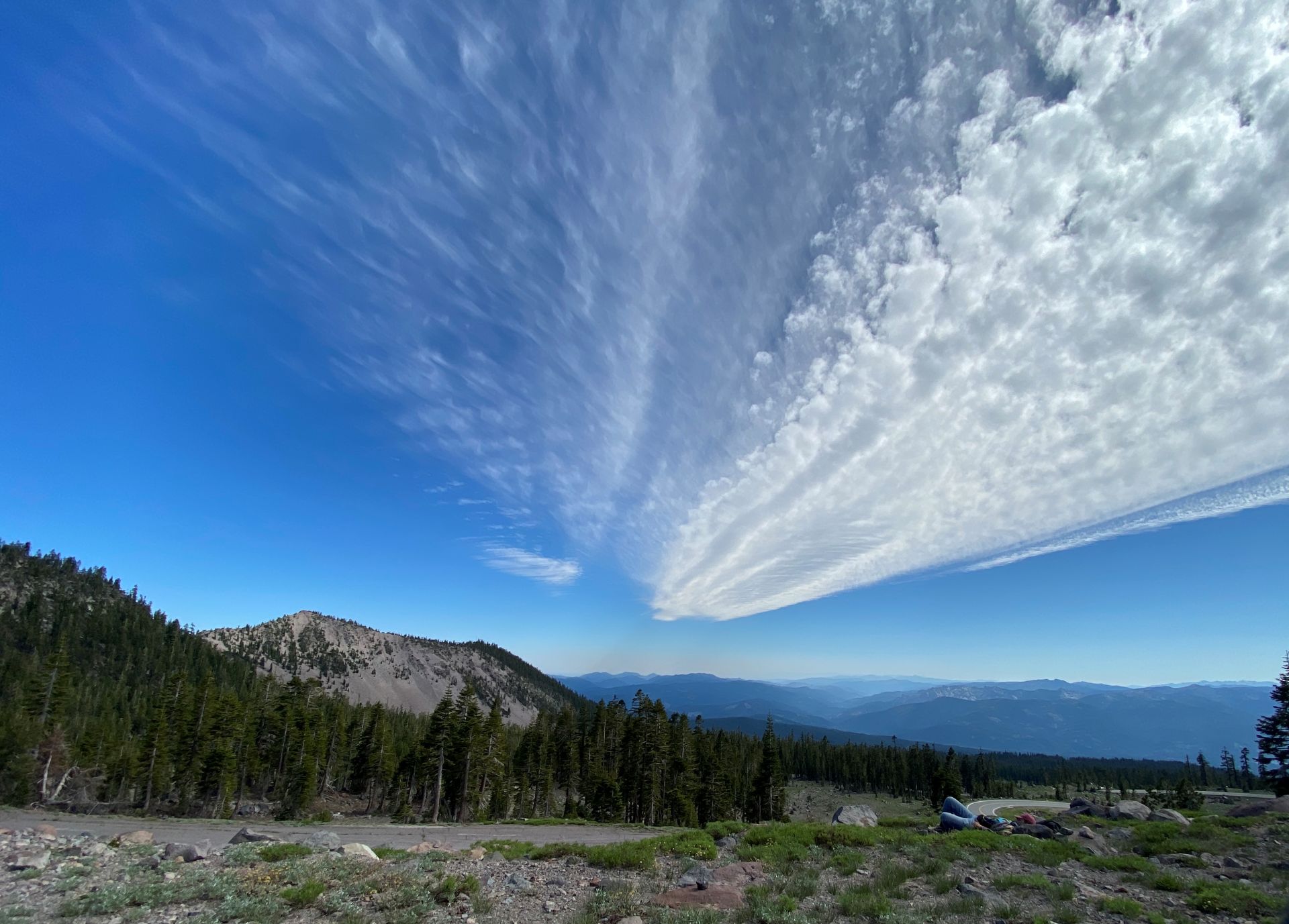
Mount Shasta is known for the lenticular cloud formations over its summit. On our visit, we saw other interesting cloud patterns, including this one that looks like a sky highway.
Sacramento River Headwaters
Aside from our multiple trips up Mount Shasta, we also walked around town. We bumped into a lot of happy people, found some pretty good Chinese food, walked through a crystal shop, tried to meet up with someone from the old days…
Before we left for home, we headed to Mount Shasta City Park. The Sacramento Headwaters, or Big Springs, are located at the base of Spring Hill.
The Sacramento River is an interesting body of water, 447 miles long. Originating from multiple counties in Northern California, this river brings life to countless. The headwaters are known for being pure and so people from all over come to the park. It takes decades for the snowmelt and rainfall to trickle and flow through lava tubes to the spring here. Many people come with jugs to pot this water, drink directly from it, or just sit quietly by it. Residents of Mount Shasta get this pure water from their tap.
You can reach Mount Shasta City Park by going down Mt Shasta Boulevard and following the discrete brown signs. Since it’s always busy, other cars will show you where to park. From there, it’s a short walk to the spring.
There is so much more to explore and experience at Mount Shasta. These few days were memorable and quite an initiation. Consider some of these books in your research of the mysterious of Mount Shasta – Mount Shasta CA Visitors Guide by P Miller, The Portals and UFOs of Mount Shasta by Grant Cameron, and Telos.